|
N12°13.062'/ W001°32.619' Extended
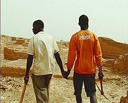
Through the GPS coordinates, the title of the film identifies precisely, but abstractly, a location in Africa. As we follow two men roaming through this location, we discover a site that is by all appearances an archeological ruin. Yet, the images reveal this site to be the work of two labourers. They have sculpted thousands of bricks directly into the rock as if it were a piece of negative cityscape. This residual space is the inverted image of a planified city. At first sight, it is a document of the irregular practice of urban planning in Africa. But protocol used in filming and the addition of fictitious details, mean that it is also a factual fiction, which must be read on a metaphorical level. The workers play their own role as if they were moving projections. The names they are wearing on their T-shirts recall fictional literary characters, clues that indicate the possibility of other parallel readings.
N12°13.062'/ W001°32.619' Extended, be, 2005, 8:25
|
|


